


SURFACE LANDSCAPE PROCESSES UNDER EARTH’S CHANGING CLIMATE ANALYZED USING SATELLITE RADAR INTERFEROMETRY
Earth’s surface evolves through interactions between the lithosphere, atmosphere, biosphere, and hydrosphere, with climate playing a crucial role in driving processes such as rock weathering, erosion, and tectonic shifts. The rapid changes observed in the modern climate, driven by anthropogenic carbon emissions, have led to a notable increase in global temperatures with a rise of over 1.5°C since pre-industrial times. This dramatic shift in the global climate is expected to significantly impact Earth's surface processes, reshaping landscapes in unprecedented ways.
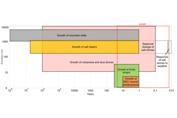
This study applies advanced Interferometric Synthetic Aperture Radar (InSAR) techniques to investigate climate-sensitive landforms: salt glaciers in the Dead Sea region and explosive gas emission craters (GECs) in Arctic permafrost. Over an observation period of 9.5 years, InSAR data reveal short-term responses of Mt. Sedom’s salt glacier to seasonal temperature changes and significant rainfall events. Additionally, remote sensing analysis distinguishes between traditional pingos and rapidly forming, warming climate-induced GEC predecessors in Arctic permafrost. These findings underscore the value of advanced remote sensing in monitoring Earth’s surface dynamics and improving our understanding of climate-driven landscape evolution.
Lastly, the challenges associated with handling large-scale SAR datasets were recognized in the above studies. As a result, a novel compression strategy was developed for complex SAR images, facilitating efficient data management without compromising analytical accuracy. This advancement enhances the accessibility and efficiency of InSAR analyses, supporting comprehensive monitoring of Earth's rapidly changing landscapes.
Additional information: Miss YIP Man Wai Michelle, myip003@hku.hk